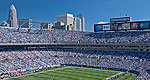
Skyscrapers define the skyline of North Carolina city Charlote, the "Wall Street of the South", an urban center home also to an assortment of museums, a NASCAR speedway and an artificial whitewater river.
This enjoyable rural route runs along the Upper Yadkin River from the rolling Brushy Mountains near Wilkesboro to the foothills and mountains of Pisgah National Forest. Spend some time winding through the pastures and farmlands of North Carolina before entering "Happy Valley," home to Revolutionary War hero General Lenoir. The drive will end near the base of Pisgah National Forest, a gem in its own right.
We offer a compact version of Go-North-Carolina for mobile users, allowing you to access just the information you need on the road. Of course, you can still use the full version of Go-North-Carolina on your mobile device just as you can on your desktop.