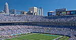
Skyscrapers define the skyline of North Carolina city Charlote, the "Wall Street of the South", an urban center home also to an assortment of museums, a NASCAR speedway and an artificial whitewater river.
This is a narrow single track with steep sections. View of the lake from the bluffs.
Permitted uses: Foot and bike
ADA accessible: No
Pets: Yes
Details
Location:
Highline Lake State Park, northwest of Grand Junction
Length:
3.4 mile roundtrip
Difficulty:
Difficult
Time:
1.5 to 2 hours
Trailhead Elevation:
4700
Map + Directions
Basic Directions
Highline Lake State Park
Drive west on I-70 west from Grand Junction to Loma Exit, then north onto Colorado Highway 139 for six miles to Q Road. Go west on Q road for 1.2 miles, then turn north onto 11.8 Road for one mile to the park entrance.
We offer a compact version of Go-North-Carolina for mobile users, allowing you to access just the information you need on the road. Of course, you can still use the full version of Go-North-Carolina on your mobile device just as you can on your desktop.