


Contact Info
Manteo, NC 27954
- Phone:
- 252-473-2111
Basics
- Type:
- National Park
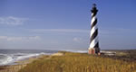
Description
A haven for recreation and reflection, the islands of Cape Hatteras are constantly changed by tide, storm, current and wind. The plants, wildlife and people who live here adapt continually. You see in their daily lives and hear it in the telling of their stories. And there are many story places - sandy beaches, salt marshes, maritime woods - explore them all.
Hours + Fees
Hours:
Cape Hatteras National Seshore is open year-round.
The Bodie Island, Hatteras Island, and Ocracoke Island Visitor Centers are open and 9 am to 6 pm daily during summer months and from 9 am to 5 pm daily September through May (closed Christmas).
The summer program schedule generally runs mid-June through Labor Day.
The Cape Hatteras Lighthouse is open for climbing generally mid-April through Columbus Day (early October).
National Park Service campgrounds at Oregon Inlet, Frisco, and Ocracoke are generally open Easter weekend through Columbus Day. The Cape Point Campground is generally open Memorial Day through Labor Day.
Map + Directions
Basic Directions
The northern entrance of Cape Hatteras NS is located at the junction of US-64 and NC-12 South in Nags Head, NC. The Seashore's southern entrance is located on NC-12 North just north of Ocracoke, NC (assessible by ferry only).
To reach the Seashore's northern entrance:
From the North
Follow I-95 South to Richmond, VA. Take I-64 East toward Norfolk/Virginia Beach, Va. Take I-64 or I-664 to Chesapeake, Va. From I-64, take Exit 291B to Route 168, the Chesapeake Expressway. Once in North Carolina, Route 168 turns into US-158 East. Follow US-158 through Nags Head, NC to the junction of NC-12 South.
From the West - Via I-95 into North Carolina.
Take US-64 East toward Rocky Mount. Follow US-64 East through Williamston and Plymouth, NC. From Plymouth, NC keep going east to Nags Head, NC and the junction of NC-12 South.
From the South - Coming from South Carolina
Take I-95 to Wilson, NC. Take US-264 East through Greenville and Washington, NC. From Washington, take State Route 30 to Plymouth, NC and follow US-64 East to Nags Head, NC and the junction of NC-12 South.
To reach the Seashore's southern entrance:
Via the Cedar Island Ferry
From I-40 East, take Exit 306 to US-70 East. Follow US-70 East to Sea Level, NC. In Sea Level, take NC-12 North to the ferry terminal. The Cedar Island Ferry crosses the Pamlico Sound to Ocracoke Village. Follow NC-12 North to the Seashore entrance. Ferry crossing time is 2.25 hours and reservations are required.
Via the Swan Quarter Ferry
Take USA-264 to NC-45 in Swan Quarter. Follow NC-45 South through town to the Hyde County Courthouse. At the courthouse, turn on Oyster Creek Road (SR-1128) and follow to the terminal. The Swan Quarter Ferry crosses the Pamlico Sound to Ocracoke Village. Follow NC-12 North to the Seashore entrance. Ferry crossing time is is 2.5 hours and reservations are required.

